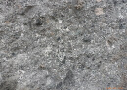
Hi, would anyone by chance know what is the conglomerate in the attached picture? Any additional information regarding notable minerals and origin is warmley welcomed. Regards
Sign up to join our community!
Lost your password? Please enter your email address. You will receive a link and will create a new password via email.
Please briefly explain why you feel this question should be reported.
Please briefly explain why you feel this answer should be reported.
Please briefly explain why you feel this user should be reported.
Hi, would anyone by chance know what is the conglomerate in the attached picture? Any additional information regarding notable minerals and origin is warmley welcomed. Regards
Water gaps are formed through the erosive action of rivers carving through resistant rock formations over millions of years. They occur when a river cuts through a ridge or mountain range, creating a gap or passageway. While water gaps can be large and impressive, they are not necessarily evidence fRead more
Water gaps are formed through the erosive action of rivers carving through resistant rock formations over millions of years. They occur when a river cuts through a ridge or mountain range, creating a gap or passageway. While water gaps can be large and impressive, they are not necessarily evidence for a catastrophic flood. Instead, they are typically formed through the slow and steady process of erosion by flowing water over geologic time scales. However, some creationists have interpreted water gaps as evidence for a catastrophic flood, although this interpretation is not supported by mainstream geological science.
See lessThe physical and engineering properties of rock can vary widely depending on factors such as composition, structure, porosity, and moisture content. Some key properties include: 1. **Density**: The mass per unit volume of the rock. It's typically measured in grams per cubic centimeter (g/cm³) or kilRead more
The physical and engineering properties of rock can vary widely depending on factors such as composition, structure, porosity, and moisture content. Some key properties include:
1. **Density**: The mass per unit volume of the rock. It’s typically measured in grams per cubic centimeter (g/cm³) or kilograms per cubic meter (kg/m³).
2. **Porosity**: The percentage of void spaces (pores) within the rock. It affects the rock’s ability to hold fluids and can influence its strength and durability.
3. **Permeability**: The ability of fluids to flow through the rock. It depends on factors such as pore size, connectivity, and fluid viscosity.
4. **Compressive Strength**: The ability of the rock to withstand axial loads without failure. It’s typically measured in units of pressure, such as megapascals (MPa) or pounds per square inch (psi).
5. **Tensile Strength**: The ability of the rock to withstand tension forces without breaking. It’s usually lower than compressive strength and varies greatly depending on the type of rock.
6. **Shear Strength**: The resistance of the rock to sliding along internal planes. It’s important in engineering for stability analysis of slopes and foundations.
7. **Weathering Resistance**: The rock’s ability to withstand weathering processes such as freeze-thaw cycles, chemical dissolution, and abrasion.
8. **Abrasion Resistance**: The resistance of the rock to wearing away due to frictional forces.
9. **Elasticity**: The ability of the rock to deform reversibly under stress and return to its original shape when the stress is removed.
10. **Anisotropy**: Some rocks exhibit different properties depending on the direction of measurement due to their layered or foliated structure.
Understanding these properties is crucial in various fields such as civil engineering, geology, mining, and construction, as they dictate the suitability of the rock for specific applications and the methods needed for excavation, reinforcement, and support.
See lessDoes the gravitational pull of the moon contribute to earths active geology?Earths molten interior should be effected just as the tides are by the gravitational pull of the moon.
The statement that oceanic crust cannot be older than 200 million years is based on the process of plate tectonics and the concept of seafloor spreading. Oceanic crust is continuously being created at mid-ocean ridges through volcanic activity, where magma rises to the surface, cools, and solidifiesRead more
The statement that oceanic crust cannot be older than 200 million years is based on the process of plate tectonics and the concept of seafloor spreading. Oceanic crust is continuously being created at mid-ocean ridges through volcanic activity, where magma rises to the surface, cools, and solidifies, forming new crust. As this process occurs, older crust is pushed away from the ridge and eventually subducted beneath continental plates or other oceanic crust in subduction zones.
Since the theory of plate tectonics suggests that the oldest oceanic crust is typically no more than around 200 million years old, this implies that older oceanic crust has been recycled back into the Earth’s mantle through subduction. This process effectively renews the oceanic crust, preventing it from accumulating to ages much older than 200 million years.
However, it’s important to note that there are exceptions to this general rule. Some fragments of ancient oceanic crust, known as ophiolites, can be found in certain geological settings, such as mountain belts, where they have been preserved and uplifted through tectonic processes. These ophiolites provide valuable insights into the history and evolution of oceanic crust, but they are relatively rare compared to the ongoing formation and recycling of younger oceanic crust at mid-ocean ridges and subduction zones.
See lessMantle is a largest part of Earth, 3000 km thick. Magma is molted material with high portion of SiO2 conponent. There fore, magmatic rocks are consistrd of si locate minerals. Magma is called lava when om surface. Most eruptions are caused by significant amount of water sliding down to volcanic cratRead more
Mantle is a largest part of Earth, 3000 km thick. Magma is molted material with high portion of SiO2 conponent. There fore, magmatic rocks are consistrd of si locate minerals. Magma is called lava when om surface. Most eruptions are caused by significant amount of water sliding down to volcanic crater, later when heated working as a fuel for eruption. In such cases, eruption trows rocks, vapor and lava onto surface. But, rearest and deadliest type of eruption is a hot spot eruption. It occurs when there is high concentration of ultramafic magma in a buble (gigant one), much hotter and less dense than sorounding magma. In such casec, eruption brings mostly lava, only small portion of rocks and vapor.
See lessThe Paleogene-Neogene boundary, formerly known as the Tertiary boundary, is defined by a significant climate event called the Grande Coupure. This event, occurring around 33.9 million years ago, marked a shift in mammalian fauna, with many extinctions and the emergence of new species.
The Paleogene-Neogene boundary, formerly known as the Tertiary boundary, is defined by a significant climate event called the Grande Coupure. This event, occurring around 33.9 million years ago, marked a shift in mammalian fauna, with many extinctions and the emergence of new species.
See less
Flat areas on steep slopes can form through a variety of geological processes: 1. **Erosion and Weathering**: Over time, the continuous action of water, wind, ice, and gravity can erode the surface of steep slopes, gradually wearing them down and creating flat areas. This process is especially promiRead more
Flat areas on steep slopes can form through a variety of geological processes:
1. **Erosion and Weathering**: Over time, the continuous action of water, wind, ice, and gravity can erode the surface of steep slopes, gradually wearing them down and creating flat areas. This process is especially prominent in regions with softer rock types or less resistant materials.
2. **Deposition**: Sediment transported by rivers, glaciers, or mass wasting events can accumulate at the base of steep slopes, forming flat areas known as alluvial fans or floodplains. These deposits build up over time and create relatively flat surfaces.
3. **Tectonic Uplift and Subsidence**: Tectonic forces can uplift or subside sections of the Earth’s crust, creating flat areas on steep slopes. For example, tectonic uplift can raise sections of a slope, resulting in flat terraces or benches, while subsidence can lower parts of the slope, forming flat depressions.
4. **Volcanic Processes**: Lava flows from volcanic eruptions can cover steep slopes and solidify into flat surfaces such as lava plateaus or plains. These volcanic deposits create extensive flat areas on the flanks of volcanoes.
5. **Mass Movement**: Mass wasting processes such as landslides, rockfalls, and debris flows can reshape steep slopes and create flat areas where material has been displaced or deposited. These events can occur due to factors such as slope instability, seismic activity, or heavy rainfall.
6. **Biological Activity**: The growth of vegetation on steep slopes can contribute to the formation of flat areas by stabilizing the surface and promoting soil development. Over time, the accumulation of organic matter and root systems can create relatively flat terraces or platforms.
Overall, the formation of flat areas on steep slopes is influenced by a combination of geological, geomorphological, and environmental factors, with processes acting over various timescales to shape the landscape.
See less