Sign Up

Sign up to join our community!

Sign In

Forgot Password

Lost your password? Please enter your email address. You will receive a link and will create a new password via email.

You must login to ask a question.

GEOLOGY HUB Latest Articles

The Cone Penetration Test (CPT) is a widely used in-situ testing method in geotechnical engineering for determining the geotechnical properties of soils. The CPT provides continuous or semi-continuous data on soil stratigraphy and properties such as soil type, relative density, shear strength, and other parameters relevant to foundation design and soil behavior analysis.

images28129616812956051361934

CPT Procedure

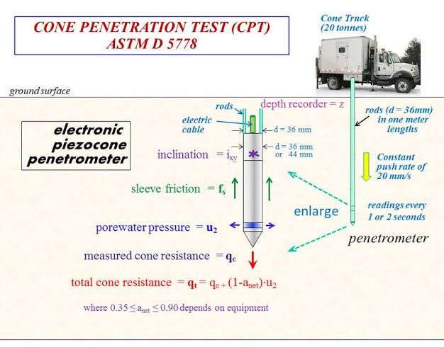
  1. Equipment Setup: The test uses a cone penetrometer, which is a cylindrical rod with a conical tip and friction sleeve. The standard cone has a tip angle of 60 degrees and a base area of 10 cm². The penetrometer is mounted on a rig (often truck-mounted or mobile) equipped with a hydraulic pushing system to advance the cone into the ground.
  2. Penetration Process: The cone penetrometer is pushed into the ground at a constant rate, typically 2 cm/s (± 20%).During penetration, measurements are taken continuously or at regular intervals for parameters such as tip resistance (qc), sleeve friction (fs), and pore water pressure (u).
  3. Data Acquisition:
  • Tip Resistance (qc): The resistance offered by soil to the penetration of the cone tip, measured in MPa. It indicates the soil’s strength and bearing capacity.
  • Sleeve Friction (fs): The frictional resistance along the cylindrical surface of the penetrometer sleeve, measured in kPa. It helps in identifying soil type and stratigraphy.
  • Pore Water Pressure (u): Measured using a piezocone (CPTu), which includes a pore pressure transducer. Pore pressure data is critical for understanding soil behavior especially in saturated and fine-grained soils.
  1. Interpretation of Results:
  • The acquired data is used to generate profiles of tip resistance, sleeve friction, and pore water pressure with depth.
  • These profiles are interpreted to identify soil layers, determine soil type, and estimate geotechnical properties.

Uses of CPT Data

  1. Soil Classification:
  • CPT data is used to classify soils based on empirical correlations. Soil behavior type (SBT) charts, developed from CPT data, help in distinguishing between sands, silts, clays, and mixtures.
  1. Estimation of Geotechnical Properties:
  • Relative Density and Compaction: For sandy soils, the relative density and degree of compaction can be estimated.
  • Shear Strength: Correlations between CPT tip resistance and undrained shear strength are used for clays and silts.
  • Bearing Capacity: The CPT provides direct measurements that can be used to estimate the bearing capacity of foundations.
  • Settlement Prediction: The data helps in predicting settlement behavior of soils under loads.
  1. Soil Stratigraphy:
  • Continuous profiles obtained from CPT are invaluable for identifying soil layers and detecting interfaces between different soil types.
  1. Liquefaction Potential:
  • In seismic regions, CPT data is used to assess the susceptibility of sandy soils to liquefaction during earthquakes.

Advantages of CPT

  • Continuous Data: Provides continuous profiles of soil properties with depth, offering a detailed view of subsurface conditions.
  • Speed and Efficiency: Quick to perform, providing immediate results.
  • Accuracy: Offers reliable and reproducible data, with less operator dependency compared to some other methods.
  • Minimal Disturbance: Causes minimal disturbance to the soil, preserving the in-situ state more effectively than other tests.

Limitations of CPT

  • Limited to Certain Soil Types: CPT is less effective in very hard or dense soils and cannot penetrate gravels or rock.
  • Initial Cost: Requires specialized equipment, which can be costly.
  • Interpretation Complexity: Data interpretation requires expertise and can be complex, particularly in layered or mixed soil conditions.
  • Pore Pressure Dissipation: In low permeability soils, pore pressure dissipation tests can take significant time, potentially delaying results.

Conclusion

The Cone Penetration Test (CPT) is a powerful tool in geotechnical site investigations, providing detailed and continuous profiles of soil properties. Its ability to rapidly and accurately assess subsurface conditions makes it invaluable for foundation design, soil classification, and assessing geotechnical risks. Despite some limitations, the CPT’s advantages in speed, efficiency, and data quality ensure its widespread use in geotechnical engineering. Proper interpretation of CPT results, combined with other site investigation methods, leads to a comprehensive understanding of ground conditions and supports effective geotechnical design.

Leave a comment

You must login to add a new comment.

Latest Geology Articles

GEOLOGY HUB Latest Articles

Porphyry Copper Deposits: Formation Processes and Economic Significance

Porphyry copper deposits are among the most significant sources of copper globally, accounting for over 60% of the world’s copper production . 1. Geological Overview a) Geological Background Porphyry copper deposits are typically associated with magmatic arcs related to subduction zones, where an oceanic plate subducts beneath a continental or ...

Ore-Bearing Hydrothermal Fluids: Key Drivers in Mineral Deposit Formation

Introduction Ore-bearing hydrothermal fluids are one of the most important agents in the formation of mineral deposits. These fluids, which originate from various geological processes, have the ability to dissolve, transport, and deposit metals in economic concentrations. The study of hydrothermal fluids is crucial for understanding ore genesis and guiding ...

How to Identify Gold-Bearing Rocks in the Field: A Geologist’s Guide

Gold has been one of the most sought-after minerals for centuries due to its value and rarity. Prospectors, geologists, and even hobbyists often search for gold-bearing rocks in the field. But how do you identify rocks that contain gold? This guide will provide an in-depth look at the geological features, ...

Alteration in Geology: Types, Processes, and Significance

Introduction Alteration in geology refers to mineralogical, textural, and chemical changes in rocks due to interactions with fluids, temperature variations, and pressure changes. This process occurs in diverse geological settings, including hydrothermal systems, weathering environments, and metamorphic terrains. Understanding alteration is essential in mineral exploration, petrology, geotechnical engineering, and environmental ...

Induced Polarization Method in Sulfide Ore Exploration

Introduction The Induced Polarization (IP) method is one of the most effective geophysical techniques used in the exploration of sulfide ore deposits. This method is particularly useful for identifying disseminated sulfide minerals, which are commonly associated with copper (Cu), gold (Au), silver (Ag), zinc (Zn), and lead (Pb) deposits. This ...

Pathfinders for Gold Deposits

Introduction Gold exploration is a complex process that requires a combination of geological knowledge, geochemistry, and geophysical techniques. One of the most effective methods for locating gold deposits is the identification of pathfinder elements and minerals. Pathfinder elements and minerals are geochemical indicators that suggest the presence of gold nearby, ...

The Crucial Role of Structural Control in Hydrothermal Gold Deposits

Introduction Structural control is one of the most significant factors influencing the formation and distribution of hydrothermal gold deposits. Structural geology determines the pathways for mineralizing fluids, the locations of ore deposition, and the overall geometry of gold-bearing zones. Understanding these structural controls is essential for exploration geologists seeking new ...

What is Geology? Defination, Importance, Branches and Facts

Introduction to Geology Geology, derived from the Greek words geo (Earth) and logos (study), is the scientific discipline dedicated to understanding the Earth’s composition, structure, processes, and history. It seeks to answer fundamental questions: How did mountains form? Why do volcanoes erupt? What clues do rocks hold about ancient life? ...

Engineering Geological Tests: Purpose, Types, and Applications

Engineering geological tests are critical for assessing the physical, mechanical, and chemical properties of rocks and soils to ensure safe and cost-effective design of infrastructure (e.g., dams, tunnels, foundations). These tests help determine material strength, stability, permeability, and susceptibility to hazards like landslides or subsidence. Below are key tests categorized ...

What is sand dunes,Types of Sand Dunes and formation?

Sand Dune Landform: Formation, Types, and Significance Sand dunes are dynamic landforms created by the interaction of wind, sand, and vegetation. These striking natural features are common in deserts, coastal regions, and even in some semi-arid and arid zones. This article explores every aspect of sand dunes, including their formation, ...

All Geology Articles